CARLA, or Computerized Approach to Residential Land Analysis, is a proprietary software package developed in-house by Willis and Associates, Inc. Architects and Planners (WAI) from 1971. The rapid assessment tool was publicly introduced through marketing brochures in 1974 as the logical application of “space age” technologies. It was designed to address the complexities of large-scale suburban land development facing builders, developers, and environmental planners at the time.
Film: How CARLA Works
The Context
Tumultuous currents of social and ideological change fueled the developments of the 1960s and early 1970s. In 1969 the United States succeeded in landing astronauts Neil Armstrong and Edwin Aldrin on the Moon, where they completed the first lunar walks. New technologies advanced space exploration and opened many other new frontiers. At the same time, however, political and socio-economic pressures confronted the nation, giving rise to record rates of inflation, an energy crisis, and heightened environmental awareness and concerns. Two building depressions nearly paralyzed the construction development market. Architectural historian Leland Roth lamented that “the result was a serious business recession during the 1970s that decimated, if not closed, many architectural offices.” Willis and her associates recognized the need to find a niche where architectural work was still viable.
Beverly Willis’ Vision
Where others saw limitations, Willis saw opportunities, and she took a series of calculated risks that positioned her firm to succeed and grow in a climate where others failed. During the 1970s, large-scale, multi-acre, multi-family condominium communities emerged as a new concept. Prohibitive expense was associated with building on hillsides versus building on flat land. In 1971, she urged her firm to undertake the planning and design of environmentally sound, multi-unit housing development projects on challenging sites, supported by newly developed computer technologies, some developed during WW2.
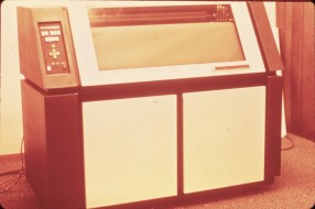
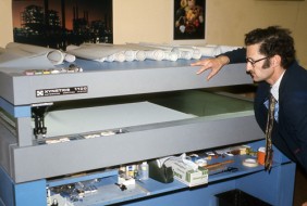
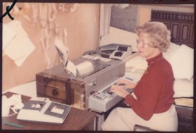
Developing software in the early 1970s was an ambitious and expensive venture. At this time private use of computers was limited to fairly large corporations. Universities such as Harvard, MIT, and Stanford housed their own Computer Research Labs to support hardware and software research. The capabilities and potentials of the “computer” were relatively unknown to most of the public. Firms like Microsoft, Apple, and Google did not exist, nor did personal desktop and laptop computers, portable reading devices, or smart phones. Still using time-shared mainframe computers, punched cards and paper tape, the technology had not yet entered mainstream American culture.
Getting Ready for CARLA
During World War II, a teenaged Willis served as a pilot; at seventeen, she was a Lieutenant in the Civil Air Patrol. In conversations with military pilots she had learned of a computer mapping program that drew bombing site perspectives. Now, many years later, she remembered and decided to locate this software to evaluate its usefulness for land planning. She found the program at the Kansas Geological Survey department (KGS) at the University of Kansas.. The KGS maintained a series of programs originally developed during World War II that were later adapted for commercial use by American oil companies. By 1971 it had also incorporated SYMAP, a mapping utility from the Harvard Laboratory for Computer Graphics and Spatial Analysis to develop a new mapping package called SURFACE II.
Willis was interested in SURFACE II and in adapting it to her needs, but because the University of Kansas is a public, non-profit institution, it could not sell the product directly to her (or to any private individual) for commercial use. However, because her interest in applying the software to land development and urban planning complemented a potential research direction the KGS wished to explore, the two parties were able to reach an agreement. The collaboration proved to be a success. The KGS refined SURFACE II’s programming to include the production of precise drainage map algorithms, slope analysis, and cut and fill diagrams. The new version was also closely linked to SYMAP.
Although SYMAP produced land drawings, it did not yet support the land planning process required to determine the type of housing that could be placed on the land, nor the exact location or cost of the buildings. Willis contacted the Stanford Engineering department, which explained that first, Willis would need to conduct a system analysis of the design flow of land planning. Willis then turned to the Harvard Graduate School of Design (GSD) for suggestions on how to get this done. She was referred to Eric Teicholz, associate director of the Harvard Laboratory for Computer Graphics and Spatial Analysis, whom she retained as a consultant.
Teicholz reviewed the SYMAP applications by KGS. He also recommended to hire Jochen Eigen, a young architect and Harvard graduate student from Germany who had worked extensively on purpose-driven planning methods and who had just learned at Harvard about early computer applications and BASIC programming. In the summer of 1971, Eigen had completed his first year of a two-year Master’s program in Urban Design. The program’s Dean, Prof. Willo von Moltke, agreed to let Eigen work with Willis’s firm in San Francisco for his third semester and conduct a formal case study of WAI’s innovative research and development efforts. To help secure academic credit for this semester from Harvard, Horst Rittel, professor for design theory and methods at the University of California in Berkeley, agreed to supervise Eigen.
Designing and Assembling CARLA
Jochen Eigen analyzed and documented the WAI land planning process by interviewing and working with the firm’s professional staff. He also helped with establishing an extensive data base of generic housing units and with lining up available mapping applications that could be used in the land-planning process. He then wrote a series of computer programs that filled the gaps and integrated the various elements into a coherent and practical planning process – a rapid assessment tool for residential land analysis that would ultimately evolve to become CARLA. (See flow chart of how the various programs interfaced)
Once the CARLA process was designed, it was put together from three basic ingredients – The SYMAP mapping and spatial analysis utilities, 1000s of residential planning units created and developed into a systematic data base by WAI staff, and the computer programs Eigen wrote (Massing of Alternative Configurations – MAC, Planning Unit Analysis – PUA, and Site Area Allocation – SAA) to weave all the elements together.
How CARLA worked
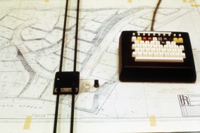
CARLA was applied in a series of steps. First, data from traditional sources, such as analog topographical maps, geological soil surveys, environmental characteristics, planning regulations and marketing information was digitized into the project information system. Second, SYMAP utilities helped to analyze mapped information. Then, WAI’s proprietary software programs interfaced the results with WAI’s library of residential planning units. Finally, a range of alternative site planning schemes could be quickly developed and evaluated.
More specifically, once the site’s contours, derived from topographical maps or individual data points, were digitized, the computer could generate custom contour maps and 3D perspectives of the site from any view point. In addition, CARLA could plot natural drainage patterns, conduct slope analyses, as well as identify areas requiring cut and fill and create “before and after” site perspectives. Areas of common building suitability were identified by overlaying maps showing relevant site characteristics.
Further, using the CARLA information base and process tools, multiple site planning concepts could be generated and evaluated in terms of their benefits and costs. CARLA was then able to help determine for each concept how many building units, in what variety, and at what cost could be built on the site. By repeating these tests for different planning unit concepts, the most environmentally and economically acceptable configuration for the site was determined.
The final reports were presented in mixed media, making use, to the extent possible, of computer generated material including maps and graphics(such as site perspectives and drainage maps) and quantitative presentations in tabular form or as a matrix that can show two sets of variables and the relations between them. This work later became the basis for site development engineering, phased design and construction documents, working drawings for the residential units, and even for marketing.

The first fully-fledged application of CARLA made history in 1973. The Pacific Points Apartments project was located in Pacifica, California, on a sloping 9-acre beachfront site with spectacular views of the Pacific Ocean. The site presented enormous physical, environmental and regulatory challenges that had frustrated earlier efforts to keep residential units affordable to moderate-income buyers. The problem was how to do this on unstable, sloping land that composed part of the site and limited the placement of buildings. The first developer that owned the site and sold it to Alpha Land was unable to solve this problem. Willis elected to use their recently created CARLA program. Thus, Pacific Point became the first development whose design resulted from the use of the CARLA program. When one of the largest US residential developers contracted WAI, CARLA was used to plan for 96 apartments and helped to make the development a great success not only for the Pacifica coastal environment, the existing community, the new residents, but also for the developer.
Based on success stories such as the Pacific Points Apartments, WAI was contracted by a variety of developers to apply CARLA to many different types of residential projects throughout the United States. One of the largest projects that used CARLA during its initial rapid assessment phase was the Aliamanu Valley Community for Military Family Housing, in Honolulu, Hawaii. The US Army Corps of Engineers was planning for a military community of a total of 2,600 families. WAI was the second firm to be contracted for the project, as the first one was unable to meet the rigid budget and environmental requirements for the project. WAI was retained based on the national recognition for its expertise in designing large-scale multi-housing complexes on challenging sites using their computer program CARLA. The Aliamanu site presented a very special situation. The 524-acre site is in a cup-like crater valley with hills sharply rising on two sides, and a crater floor of deep clay. WAI met the project goals of planning, designing, and engineering the 525 buildings within nine months. The phased design and construction documents for the project were completed in 1978. Construction also was completed in record time.
CARLA’s contribution to Environmental Impact Reporting (EIR)


Depending on the characteristics of the residential land being assessed, CARLA facilitated consideration of a wide range of environmental concerns from natural resources to be managed (such as sensitive aquifers and critical habitats) to environmental hazards to be avoided (such as flood-prone areas, unstable slopes, and seismic risks). This sensitivity of the CARLA process to the environment had good reasons. First of all, good site planning has always been sensitive and responsive to the opportunities and constraints of its natural and man-made setting. Secondly, many of the residential sites WAI worked on were environmentally unique and sensitive and Willis and her staff had developed a deep appreciation for the functional relationships between natural forces and the built environment.
Another important reason for CARLA’s responsiveness to environmental concerns is American history. CARLA was conceived in the “golden age” of the American environmental movement, when the movement had just reached a very special milestone. Developers, the public sector and civil society activists had started to understand that sound land development and responsible environmental management are not in conflict with each other but rather two sides of the same coin. The National Environmental Policy Act (NEPA), enacted in early 1970 formalized that understanding, requiring disclosure and evaluation of project effects on the environment prior to granting building permits. “From its enactment in late 1970, the California Environmental Policy Act (CEQA) had been interpreted by state and local agencies to mandate an Environmental Impact Report (EIR) only for public works,” but in late 1972, the California supreme court in Friends of Mammoth v. Board of Supervisors of Mono County declared that EIRs were also required for private development activities. “The far reaching decision caused an immediate reaction. Local governments stopped granting building permits, banks held up loans, and contractors voiced fears of a disastrous impact on the state’s economy.” However, “cities and counties soon resumed granting building permits, as the more sophisticated among them were enacting guidelines to effectuate the newly mandated EIR procedures.”
Also, some of the elements of an EIR were not necessarily unique to a specific project or project site but rather re-usable from project to project or applicable area-wide. This suggested, for example, that planners maintain libraries of generic design measures that prevent erosion or polluted storm water run-off, and that local planning departments develop information and agreed environmental policies for managing local environmental resources such as an aquifer. Preparing re-usable information, as well as policies for local environment sensitivities and hazards in advance, rather than on a project by project basis, is critical to the efficiency and timeliness of the EIR process. The WAI guidelines therefor did not only describe the issues to be addressed by the EIR process, but also the actors and stakeholders to be involved and their respective tasks and time-lines to be met. As an early result of these R&D activities, WAI provided much sought after advice to private and public development practitioners on how to handle the complex procedures required for an efficient EIR. Through these activities, Willis and her firm not only helped remove the bottleneck that had stalled residential land development in the early 1970’s, but also gained mastery in understanding the various rules and procedures. This expertise would prove to be a valuable asset for her firm and her clients.
Conclusion: CARLA’s benefits
Willis’s primary motivation in developing CARLA was to create minimal-impact sustainable housing, through environmentally sound decision making that supported the efficient use of land, appropriate allocation of density, and reduced reliance on excavation and grading. But CARLA’s development also produced other significant benefits. Between 1971 and 1974, the amount of time required to fully develop a new community nearly doubled. Eugene Rosenfeld, president of the construction firm Kaufman & Broad Inc., noted in a real estate column that “consumerism, environmentalism, and energy related difficulties [had] cumulatively re-written the rules and lengthened the time frame for housing production in the US.” CARLA devised development strategies that limited excavation demands on a proposed site, significantly reducing labor and materials usage. This allowed developers to cut their costs by 20 percent and build apartments or townhouses more quickly, further optimizing profits.
Quantitatively, CARLA allowed WAI to produce during a twenty-day period what traditional methods required other architects and planners four to six months to produce. The firm was able to generate not just two or three viable proposals but 20 or 30, thereby multiplying its capacity nearly ten-fold. In 1973, The San Francisco Sunday Examiner printed the article “Computer Moves into Land Studies” emphasizing CARLA’s efficiency and cost savings potential. It noted that CARLA could process “500% more information in less time and at less cost than utilizing the more traditional methods.”
In addition, CARLA was able to accurately project development costs within a very small margin of error (roughly 3 percent), providing the developer or investor with a concept plan that nearly perfectly matched its financial objectives. CARLA’s speed and degree of accuracy allowed the builder to start construction more quickly, with less land development costs. This was a key consideration in the 1970s, when inflation rates were constantly rising and any delay could potentially introduce a significant increase in costs. The potential condominium buyer also appreciated the savings CARLA helped to realize: on one project, this equated to $2,000 per unit.
Qualitatively, CARLA achieved better, more cost-efficient, environmentally sound multi-unit developments. In addition, it advanced the profession of architecture by providing architects and land planners with a consistent information-structuring tool that allowed the professional to consider and compare multiple sets of information simultaneously, an advantage that far exceeded the scope of traditional methods. After CARLA’s iterative process had identified an optimal planning concept, the architect was then free to refine the plan further, initiate construction drawings, and address the more creative aspects of the project. As a framework for organizing information, CARLA also became an important tool for using census data to find promising sites for potential residential development.
While many firms suffered financially during the 1970s, Willis and Associates, Inc. grew in size. Amongst a larger staff, its principals included Beverly Willis, FAIA, President; David Coldoff, AIA, Executive Vice President; and Charles Rueger, AIA, Associate Designer. Jochen Eigen, Dipl.-Ing., MAUD, was now Vice President of research and development. The firm experienced a significant increase in activity with its new tool. CARLA also met with great professional and academic acclaim. Beverly Willis was asked to give presentations about the computerized land analyzing program at many conferences, and she taught the CARLA system for two summers at Harvard.
References
This partial listing organizes the articles by date.
1972
“Economic Probes, Key to Developer’s Success, enhanced by Computers” from Building Design and Construction, The Magazine of Commercial and Industrial Building. A Cahner’s Publication, June 1972. [No credit]
1973
“Savings seen in Planning by Computer. Part VI.” Los Angeles Times, September 2, 1973.
“Computer Moves into Land Studies.” San Francisco Sunday Examiner & Chronicle, September 9, 1973.
1974
Turpin, Dick. “Condo-Mania Keeps Growing.” Los Angeles Times, April 7, 1974.
“New Land Planning Techniques Change Condominium Approach.” Daily Pacific Builder, San Francisco, California, April 11, 1974.
“Condominium Market Impact: Space Age Land Planning.” Las Vegas Sun, April 14 1974. [No Credit]
Carlston, Lon M. (Tribune Real Estate Writer). “New Approach Offers Savings.” The Sunday Tribune Real Estate Section, Sunday, April 28, 1974.
“A Boost from Computers,” Marketing Information Retail, November 1974? [Received stamp 1974]
1975
Allen, Sidney P. (Financial Editor). “Land Planning, CARLA races to get Job Done.” The Chronicle, September 7, 1975.